Weather Alert in Maine
Winter Weather Advisory issued April 2 at 2:32AM EDT until April 3 at 10:00AM EDT by NWS Gray ME
AREAS AFFECTED: Southern Oxford; Southern Franklin; Southern Somerset; Androscoggin; Kennebec; Interior Waldo; Interior Cumberland Highlands
DESCRIPTION: A light wintry mix will overspread the area late this evening. The wintry mix will transition to light freezing rain late tonight into early Friday morning. * WHAT...Mixed precipitation expected. Total snow accumulations up to one inch, sleet accumulations up to one tenth of an inch, and ice accumulations around one tenth of an inch. * WHERE...Portions of south central, southwest, and western Maine. * WHEN...From 11 PM this evening to 10 AM EDT Friday. * IMPACTS...A period of mixed precipitation is expected with air temperatures remaining below freezing. Expect slippery road conditions and avoid travel if possible. Even light snowfall amounts can accumulate on roads and cause dangerous driving conditions due to snow covered roads. The hazardous conditions could impact the Friday morning commute.
INSTRUCTION: Slow down and use caution while traveling. The latest road conditions can be obtained by going to newengland511.org
Want more detail? Get the Complete 7 Day and Night Detailed Forecast!
Current U.S. National Radar--Current
The Current National Weather Radar is shown below with a UTC Time (subtract 5 hours from UTC to get Eastern Time).

National Weather Forecast--Current
The Current National Weather Forecast and National Weather Map are shown below.

National Weather Forecast for Tomorrow
Tomorrow National Weather Forecast and Tomorrow National Weather Map are show below.

North America Water Vapor (Moisture)
This map shows recent moisture content over North America. Bright and colored areas show high moisture (ie, clouds); brown indicates very little moisture present; black indicates no moisture.

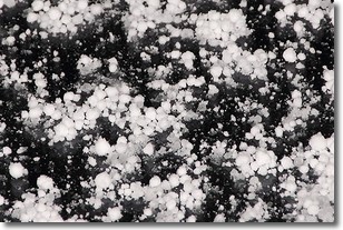
Weather Topic: What is Graupel?
Home - Education - Precipitation - Graupel
 Next Topic: Hail
Graupel is a form of precipitation that is created by atmospheric conditions
which cause supercooled water droplets to contact snow crystals and freeze to
their surface.
Sometimes known as soft hail or snow pellets, graupel is delicate and easily
destroyed by touch. Whereas hail usually falls during severe weather, graupel
doesn't require such conditions to form, and can form in mild precipitation
similar to situations which produce snowfall.
Next Topic: Hail
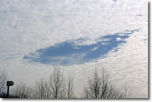
Weather Topic: What are Hole Punch Clouds?
Home - Education - Cloud Types - Hole Punch Clouds
 Next Topic: Mammatus Clouds
A hole punch cloud is an unusual occurrence when a disk-shaped
hole appears in a cirrostratus, cirrocumulus, or altocumulus cloud.
When part of the cloud forms ice crystals, water droplets in the surrounding area
of the cloud evaporate. The effect of this process produces a large elliptical
gap in the cloud. The hole punch cloud formation is rare, but it is not specific
to any geographic area.
Other names which have been used to describe this phenomena include fallstreak hole,
skypunch, and cloud hole.
Next Topic: Mammatus Clouds
Current conditions powered by WeatherAPI.com


