Weather Alert in Montana
Winter Weather Advisory issued April 2 at 2:43PM MDT until April 3 at 12:00PM MDT by NWS Great Falls MT
AREAS AFFECTED: Cascade County below 5000ft; Judith Basin County and Judith Gap; Fergus County below 4500ft; Snowy and Judith Mountains
DESCRIPTION: * WHAT...Snow expected. Storm total snow accumulations up to 3 inches, with the exception of the US Hwy 87 corridor from Belt to Raynesford and Lewistown to Lewistown Divide and the US Hwy 89 corridor from Armington Junction to Riceville where 5 to 10 inches is expected. Winds gusting as high as 40 mph may create areas of blowing and drifting snow this evening and overnight. * WHERE...Snowy and Judith Mountains, Cascade County below 5000ft, Fergus County below 4500ft, and Judith Basin County and Judith Gap. * WHEN...Until noon MDT Friday. * IMPACTS...Travel could be very difficult. The hazardous conditions could impact the evening and Friday morning commutes. Isolated power outages are possible due to the heavy, wet snow accumulating on power lines. * ADDITIONAL DETAILS...Snow accumulations on road surfaces may be limited through the afternoon hours, with impacts to travel increasing from this evening and through the morning hours on Friday as snow accumulates on roads and blowing snow reduces visibility.
INSTRUCTION: Slow down and use caution while traveling. The latest road conditions can be obtained by calling 5 1 1 or visiting the MDT Road Report website. To see a graphical representation of the degree of stress on young livestock please visit our webpage and select Local Programs then Cold Air Advisory for Newborn Livestock.
Want more detail? Get the Complete 7 Day and Night Detailed Forecast!
Current U.S. National Radar--Current
The Current National Weather Radar is shown below with a UTC Time (subtract 5 hours from UTC to get Eastern Time).

National Weather Forecast--Current
The Current National Weather Forecast and National Weather Map are shown below.

National Weather Forecast for Tomorrow
Tomorrow National Weather Forecast and Tomorrow National Weather Map are show below.

North America Water Vapor (Moisture)
This map shows recent moisture content over North America. Bright and colored areas show high moisture (ie, clouds); brown indicates very little moisture present; black indicates no moisture.

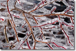
Weather Topic: What is Freezing Rain?
Home - Education - Precipitation - Freezing Rain
 Next Topic: Graupel
Freezing rain is a condition where precipitation which has fallen in the form of
water droplets reaches temperatures which are below freezing and freezes upon
coming into contact
with surface objects. The result of this precipitation is a glaze of ice which
can be damaging to plants and man-made structures. A severe onset of freezing
rain which results in a very thick glaze of ice is known as an ice storm.
Next Topic: Graupel
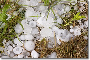
Weather Topic: What is Hail?
Home - Education - Precipitation - Hail
 Next Topic: Hole Punch Clouds
Hail is a form of precipitation which is recognized by large solid balls or
clumps of ice. Hail is created by thunderstorm clouds with strong updrafts of wind.
As the hailstones remain in the updraft, ice is deposited onto them until their
weight becomes heavy enough for them to fall to the earth's surface.
Hail storms can cause significant damage to crops, aircrafts, and man-made structures,
despite the fact that the duration is usually less than ten minutes.
Next Topic: Hole Punch Clouds
Current conditions powered by WeatherAPI.com


