Weather Alert in Maine
Winter Storm Warning issued April 2 at 4:26AM EDT until April 3 at 5:00PM EDT by NWS Caribou ME
AREAS AFFECTED: Northwest Aroostook; Northeast Aroostook
DESCRIPTION: * WHAT...Heavy mixed precipitation expected. Total snow accumulations around 4 to 7 inches, sleet accumulations up to 1 inch, and ice accumulations up to one tenth of an inch. * WHERE...Northeast Aroostook and Northwest Aroostook Counties. * WHEN...From 11 PM this evening to 5 PM EDT Friday. * IMPACTS...Roads, and especially bridges and overpasses, will likely become slick and hazardous. Plan on slippery road conditions. The hazardous conditions could impact the Friday morning and evening commutes. * ADDITIONAL DETAILS...Potential for significant sleet accumulations will make snow and sleet removal challenging. Conditions will rapidly improve during the day Friday thanks to the increasing sun angle.
INSTRUCTION: A Winter Storm Warning means significant amounts of snow, sleet, and ice will make travel extremely dangerous. The latest road conditions for Maine can be obtained by going to newengland511.org.
Want more detail? Get the Complete 7 Day and Night Detailed Forecast!
Current U.S. National Radar--Current
The Current National Weather Radar is shown below with a UTC Time (subtract 5 hours from UTC to get Eastern Time).

National Weather Forecast--Current
The Current National Weather Forecast and National Weather Map are shown below.

National Weather Forecast for Tomorrow
Tomorrow National Weather Forecast and Tomorrow National Weather Map are show below.

North America Water Vapor (Moisture)
This map shows recent moisture content over North America. Bright and colored areas show high moisture (ie, clouds); brown indicates very little moisture present; black indicates no moisture.

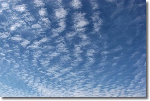
Weather Topic: What are Cirrocumulus Clouds?
Home - Education - Cloud Types - Cirrocumulus Clouds
 Next Topic: Cirrostratus Clouds
Cirrocumulus clouds form at high altitudes (usually around 5 km)
and have distinguishing characteristics displayed in a fine layer of
small cloud patches. These small cloud patches are sometimes referred to as
"cloudlets" in relation to the whole cloud formation.
Cirrocumulus clouds are formed from ice crystals and water droplets. Often, the
water droplets in the cloud freeze into ice crystals and the cloud becomes a
cirrostratus cloud. Because of this common occurrence, cirrocumulus cloud
formations generally pass rapidly.
Next Topic: Cirrostratus Clouds
Weather Topic: What are Cirrus Clouds?
Home - Education - Cloud Types - Cirrus Clouds
 Next Topic: Condensation
Cirrus clouds are high-level clouds that occur above 20,000 feet
and are composed mainly of ice crystals.
They are thin and wispy in appearance.
What do they indicate?
They are often the first sign of an approaching storm.
Next Topic: Condensation
Current conditions powered by WeatherAPI.com


