Weather Alert in Illinois
Flood Warning issued April 2 at 12:13PM EDT until April 12 at 11:17AM EDT by NWS Indianapolis IN
AREAS AFFECTED: Clark, IL; Crawford, IL; Sullivan, IN; Vigo, IN
DESCRIPTION: ...The National Weather Service in Indianapolis IN has issued a Flood Warning for the following rivers in Indiana...Illinois... Wabash River at Terre Haute. Wabash River at Hutsonville Legacy Power Plant Site. .Multiple rounds of rainfall will bring minor lowland flooding to the Wabash River basin that could hang around through much of next week. The current river forecasts include around an inch of rainfall through Saturday morning, but do not include rainfall from Saturday through Sunday. Higher rainfall amounts in the Wabash basin could increase crests or lengthen the amount of time in flood. * WHAT...Minor flooding is forecast. * WHERE...Wabash River at Terre Haute. * WHEN...From Friday evening to Sunday, April 12. * IMPACTS...At 22.0 feet, Pottsville Street just northwest of Terre Haute is flooded. Lowland flooding in progress with several river roads flooded in Clark County Illinois. * ADDITIONAL DETAILS... - At 11:30 AM EDT Thursday /10:30 AM CDT Thursday/ the stage was 10.7 feet. - Forecast...The river is expected to rise above flood stage tomorrow evening to a crest of 21.8 feet early Tuesday afternoon. It will then fall below flood stage Saturday, April 11. - Flood stage is 16.5 feet. - http://www.weather.gov/safety/flood
INSTRUCTION: Turn around, don't drown when encountering flooded roads. Most flood deaths occur in vehicles. Motorists should not attempt to drive around barricades or drive cars through flooded areas. Additional information is available at www.weather.gov/ind. The next statement should be issued late tonight by around 200 AM EDT /100 AM CDT/.
Want more detail? Get the Complete 7 Day and Night Detailed Forecast!
Current U.S. National Radar--Current
The Current National Weather Radar is shown below with a UTC Time (subtract 5 hours from UTC to get Eastern Time).

National Weather Forecast--Current
The Current National Weather Forecast and National Weather Map are shown below.

National Weather Forecast for Tomorrow
Tomorrow National Weather Forecast and Tomorrow National Weather Map are show below.

North America Water Vapor (Moisture)
This map shows recent moisture content over North America. Bright and colored areas show high moisture (ie, clouds); brown indicates very little moisture present; black indicates no moisture.

Weather Topic: What are Altocumulus Clouds?
Home - Education - Cloud Types - Altocumulus Clouds
 Next Topic: Altostratus Clouds
Similar to cirrocumulus clouds, altocumulus clouds are
characterized by cloud patches. They are distinguished by larger cloudlets
than cirrocumulus clouds but are still smaller than stratocumulus clouds.
Altocumulus clouds most commonly form in middle altitudes (between 2 and 5 km)
and may resemble, at times, the shape of a flying saucer.
These uncommon formations, called altocumulus lenticularis, are created by uplift
in the atmosphere and are most often seen in close proximity to mountains.
Next Topic: Altostratus Clouds
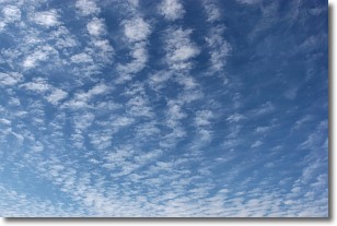
Weather Topic: What are Cirrocumulus Clouds?
Home - Education - Cloud Types - Cirrocumulus Clouds
 Next Topic: Cirrostratus Clouds
Cirrocumulus clouds form at high altitudes (usually around 5 km)
and have distinguishing characteristics displayed in a fine layer of
small cloud patches. These small cloud patches are sometimes referred to as
"cloudlets" in relation to the whole cloud formation.
Cirrocumulus clouds are formed from ice crystals and water droplets. Often, the
water droplets in the cloud freeze into ice crystals and the cloud becomes a
cirrostratus cloud. Because of this common occurrence, cirrocumulus cloud
formations generally pass rapidly.
Next Topic: Cirrostratus Clouds
Current conditions powered by WeatherAPI.com


