Weather Alert in Wisconsin
Winter Weather Advisory issued April 3 at 12:11AM CDT until April 3 at 1:00AM CDT by NWS Duluth MN
AREAS AFFECTED: Burnett; Washburn; Sawyer
DESCRIPTION: * WHAT...For the Winter Weather Advisory, mixed precipitation. Additional snow accumulations up to one inch and ice accumulations around a light glaze. For the Winter Storm Watch, heavy mixed precipitation possible. Total snow and sleet accumulations up to one inch and ice accumulations up to four tenths of an inch possible. * WHERE...Burnett, Sawyer, and Washburn Counties. This includes the Tribal Lands of the Lac Courte Oreilles Reservation and the St. Croix Band in Burnett County. * WHEN...For the Winter Weather Advisory, until 1 AM CDT early this morning. For the Winter Storm Watch, from this afternoon through Saturday morning. * IMPACTS...Power outages and tree damage are likely due to the ice. Travel could be nearly impossible. The hazardous conditions could impact the Friday morning and evening commutes.
INSTRUCTION: Slow down and use caution while traveling. Call 511 or visit www.511wi.gov for Wisconsin road information. Monitor the latest forecasts for updates on this situation.
Want more detail? Get the Complete 7 Day and Night Detailed Forecast!
Current U.S. National Radar--Current
The Current National Weather Radar is shown below with a UTC Time (subtract 5 hours from UTC to get Eastern Time).

National Weather Forecast--Current
The Current National Weather Forecast and National Weather Map are shown below.

National Weather Forecast for Tomorrow
Tomorrow National Weather Forecast and Tomorrow National Weather Map are show below.

North America Water Vapor (Moisture)
This map shows recent moisture content over North America. Bright and colored areas show high moisture (ie, clouds); brown indicates very little moisture present; black indicates no moisture.

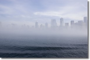
Weather Topic: What is Fog?
Home - Education - Cloud Types - Fog
 Next Topic: Fractus Clouds
Fog is technically a type of stratus cloud, which lies along the
ground and obscures visibility.
It is usually created when humidity in the air condenses into tiny water droplets.
Because of this, some places are more prone to foggy weather, such as regions
close to a body of water.
Fog is similar to mist; both are the appearance of water droplets suspended in
the air, but fog is the term applied to the condition when visibility is less than 1 km.
Next Topic: Fractus Clouds
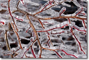
Weather Topic: What is Freezing Rain?
Home - Education - Precipitation - Freezing Rain
 Next Topic: Graupel
Freezing rain is a condition where precipitation which has fallen in the form of
water droplets reaches temperatures which are below freezing and freezes upon
coming into contact
with surface objects. The result of this precipitation is a glaze of ice which
can be damaging to plants and man-made structures. A severe onset of freezing
rain which results in a very thick glaze of ice is known as an ice storm.
Next Topic: Graupel
Current conditions powered by WeatherAPI.com


