Weather Alert in Minnesota
Winter Storm Warning issued April 4 at 10:04AM CDT until April 5 at 1:00AM CDT by NWS Grand Forks ND
AREAS AFFECTED: Roseau; Lake Of The Woods; East Marshall; North Beltrami; Pennington; Red Lake; East Polk; North Clearwater; South Beltrami; Mahnomen; South Clearwater; Hubbard; West Becker; East Becker; West Otter Tail; East Otter Tail; Wadena
DESCRIPTION: * WHAT...Heavy snow. Additional snow accumulations between 2 and 6 inches. * WHERE...Portions of central, north central, northwest, and west central Minnesota. * WHEN...Until 1 AM CDT Sunday. * IMPACTS...Roads are reported as slick and hazardous. Plan on difficult travel conditions. Heavy wet snow on power lines and tree limbs may cause sporadic power outages. Heavy wet snow has been reported to be very difficult to move. Persons with cardiac issues should use extra caution when shoveling, or avoid shoveling.
INSTRUCTION: Travel is greatly discouraged until conditions improve. The latest road conditions for the state you are calling from can be obtained by calling 5 1 1. Do not touch downed lines and report any power outages to your electric company. When shoveling heavy wet snow, take frequent breaks, stay hydrated with water, and move only small amounts with each pass.
Want more detail? Get the Complete 7 Day and Night Detailed Forecast!
Current U.S. National Radar--Current
The Current National Weather Radar is shown below with a UTC Time (subtract 5 hours from UTC to get Eastern Time).

National Weather Forecast--Current
The Current National Weather Forecast and National Weather Map are shown below.

National Weather Forecast for Tomorrow
Tomorrow National Weather Forecast and Tomorrow National Weather Map are show below.

North America Water Vapor (Moisture)
This map shows recent moisture content over North America. Bright and colored areas show high moisture (ie, clouds); brown indicates very little moisture present; black indicates no moisture.

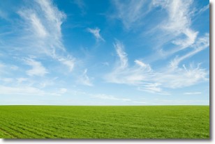
Weather Topic: What are Cirrus Clouds?
Home - Education - Cloud Types - Cirrus Clouds
 Next Topic: Condensation
Cirrus clouds are high-level clouds that occur above 20,000 feet
and are composed mainly of ice crystals.
They are thin and wispy in appearance.
What do they indicate?
They are often the first sign of an approaching storm.
Next Topic: Condensation
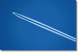
Weather Topic: What are Contrails?
Home - Education - Cloud Types - Contrails
 Next Topic: Cumulonimbus Clouds
A contrail is an artificial cloud, created by the passing of an
aircraft.
Contrails form because water vapor in the exhaust of aircraft engines is suspended
in the air under certain temperatures and humidity conditions. These contrails
are called exhaust contrails.
Another type of contrail can form due to a temporary reduction in air pressure
moving over the plane's surface, causing condensation.
These are called aerodynamic contrails.
When you can see your breath on a cold day, it is also because of condensation.
The reason contrails last longer than the condensation from your breath is
because the water in contrails freezes into ice particles.
Next Topic: Cumulonimbus Clouds
Current conditions powered by WeatherAPI.com


