Weather Alert in Missouri
Flood Advisory issued April 2 at 8:46AM CDT until April 2 at 11:00AM CDT by NWS Kansas City/Pleasant Hill MO
AREAS AFFECTED: Carroll, MO; Chariton, MO; Cooper, MO; Howard, MO; Linn, MO; Macon, MO; Randolph, MO; Saline, MO
DESCRIPTION: * WHAT...Flooding caused by excessive rainfall continues. * WHERE...Portions of central and north central Missouri, including the following counties, in central Missouri, Cooper, Howard and Saline. In north central Missouri, Carroll, Chariton, Linn, Macon and Randolph. * WHEN...Until 1100 AM CDT. * IMPACTS...Minor flooding in low-lying and poor drainage areas. * ADDITIONAL DETAILS... - At 841 AM CDT, Doppler radar indicated rain will taper off from west to east across the area over the next couple of hours. Runoff from the earlier 1.5 to 2.5 inches of rainfall will continue to produce flooding of low-lying and poor drainage areas. - Additional rainfall amounts up to a quarter inch is possible as the rain moves east of the area. - Some locations that will experience flooding include... Moberly, Marshall, Boonville, Macon, Brookfield, Fayette, Marceline, Slater, Salisbury, Huntsville, Glasgow, New Franklin, Brunswick, Bevier, Higbee, Keytesville, Bucklin, Laclede, Bosworth and Clark. - http://www.weather.gov/safety/flood
INSTRUCTION: Be aware of your surroundings and do not drive on flooded roads.
Want more detail? Get the Complete 7 Day and Night Detailed Forecast!
Current U.S. National Radar--Current
The Current National Weather Radar is shown below with a UTC Time (subtract 5 hours from UTC to get Eastern Time).

National Weather Forecast--Current
The Current National Weather Forecast and National Weather Map are shown below.

National Weather Forecast for Tomorrow
Tomorrow National Weather Forecast and Tomorrow National Weather Map are show below.

North America Water Vapor (Moisture)
This map shows recent moisture content over North America. Bright and colored areas show high moisture (ie, clouds); brown indicates very little moisture present; black indicates no moisture.

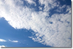
Weather Topic: What are Stratus Clouds?
Home - Education - Cloud Types - Stratus Clouds
 Next Topic: Wall Clouds
Stratus clouds are similar to altostratus clouds, but form at a
lower altitude and are identified by their fog-like appearance, lacking the
distinguishing features of most clouds.
Stratus clouds are wider than most clouds, and their base has a smooth, uniform
look which is lighter in color than a nimbostratus cloud.
The presence of a stratus cloud indicates the possibility of minor precipitation,
such as drizzle, but heavier precipitation does not typically arrive in the form
of a stratus cloud.
Next Topic: Wall Clouds
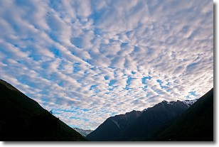
Weather Topic: What are Altocumulus Clouds?
Home - Education - Cloud Types - Altocumulus Clouds
 Next Topic: Altostratus Clouds
Similar to cirrocumulus clouds, altocumulus clouds are
characterized by cloud patches. They are distinguished by larger cloudlets
than cirrocumulus clouds but are still smaller than stratocumulus clouds.
Altocumulus clouds most commonly form in middle altitudes (between 2 and 5 km)
and may resemble, at times, the shape of a flying saucer.
These uncommon formations, called altocumulus lenticularis, are created by uplift
in the atmosphere and are most often seen in close proximity to mountains.
Next Topic: Altostratus Clouds
Current conditions powered by WeatherAPI.com


