Weather Alert in Maine
Winter Weather Advisory issued April 2 at 2:41PM EDT until April 3 at 12:00PM EDT by NWS Gray ME
AREAS AFFECTED: Northern Oxford; Northern Franklin; Central Somerset
DESCRIPTION: A light wintry mix will overspread the area late this evening. The wintry mix will transition to light freezing rain late tonight into early Friday morning. * WHAT...Mixed precipitation expected. Total snow accumulations up to one inch, sleet accumulations around two tenths of an inch, and ice accumulations between one tenth and one quarter of an inch. Winds gusting as high as 25 to 35 mph. * WHERE...Central Somerset, Northern Franklin, and Northern Oxford Counties. * WHEN...From 11 PM this evening to noon EDT Friday. * IMPACTS...A period of mixed precipitation is expected with air temperatures remaining below freezing. Expect slippery road conditions and avoid travel if possible. The hazardous conditions could impact the Friday morning commute. Gusty winds will cause extra stress to trees and could break some tree limbs. The power outage threat is limited.
INSTRUCTION: Slow down and use caution while traveling. The latest road conditions can be obtained by going to newengland511.org
Want more detail? Get the Complete 7 Day and Night Detailed Forecast!
Current U.S. National Radar--Current
The Current National Weather Radar is shown below with a UTC Time (subtract 5 hours from UTC to get Eastern Time).

National Weather Forecast--Current
The Current National Weather Forecast and National Weather Map are shown below.

National Weather Forecast for Tomorrow
Tomorrow National Weather Forecast and Tomorrow National Weather Map are show below.

North America Water Vapor (Moisture)
This map shows recent moisture content over North America. Bright and colored areas show high moisture (ie, clouds); brown indicates very little moisture present; black indicates no moisture.

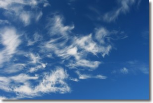
Weather Topic: What are Altostratus Clouds?
Home - Education - Cloud Types - Altostratus Clouds
 Next Topic: Cirrocumulus Clouds
Altostratus clouds form at mid to high-level altitudes
(between 2 and 7 km) and are created by a warm, stable air mass which causes
water vapor
to condense as it rise through the atmosphere. Usually altostratus clouds are
featureless sheets characterized by a uniform color.
In some cases, wind punching through the cloud formation may give it a waved
appearance, called altostratus undulatus. Altostratus clouds
are commonly seen with other cloud formations accompanying them.
Next Topic: Cirrocumulus Clouds
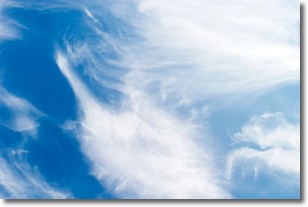
Weather Topic: What are Cirrostratus Clouds?
Home - Education - Cloud Types - Cirrostratus Clouds
 Next Topic: Cirrus Clouds
Cirrostratus clouds are high, thin clouds that form above
20,000 feet and are made mostly of ice crystals. They sometimes look like giant
feathers, horse tails, or curls of hair in the sky.
These clouds are pushed by the jet stream and can move at high speeds reaching
100 mph.
What do they indicate?
They indicate that a precipitation is likely within 24 hours.
Next Topic: Cirrus Clouds
Current conditions powered by WeatherAPI.com


