Forecast Details for Caguas, 025

Recent Locations: Blue Mounds, WI   Birchwood, WI   Caguas, 025  
Tonight: Scattered showers, mainly after midnight. Partly cloudy, with a low around 72. Southeast wind 3 to 5 mph. Chance of precipitation is 40%.
Saturday: Isolated showers before noon, then scattered showers after 3pm. Sunny, then becoming partly sunny during the afternoon, with a high near 88. South wind 7 to 11 mph. Chance of precipitation is 40%.
Saturday Night: Scattered showers, mainly before 9pm. Mostly cloudy, then gradually becoming clear, with a low around 72. Calm wind. Chance of precipitation is 40%.
Sunday: Scattered showers and thunderstorms after noon. Increasing clouds, with a high near 88. Light southeast wind becoming south southeast 5 to 9 mph in the morning. Chance of precipitation is 50%.
Sunday Night: Scattered showers and thunderstorms. Mostly cloudy, with a low around 73. Light south southeast wind. Chance of precipitation is 50%.
Monday: Isolated showers, then scattered showers and thunderstorms after noon. Mostly sunny, with a high near 88. Southeast wind 5 to 10 mph. Chance of precipitation is 50%.
Monday Night: Scattered showers. Mostly cloudy, with a low around 73. Southeast wind around 5 mph becoming calm in the evening. Chance of precipitation is 50%.
Tuesday: Scattered showers. Mostly cloudy, with a high near 87. Southeast wind 3 to 7 mph. Chance of precipitation is 50%.
Tuesday Night: Scattered showers. Mostly cloudy, with a low around 73. Calm wind. Chance of precipitation is 40%.
Wednesday: Scattered showers. Partly sunny, with a high near 87. Chance of precipitation is 40%.
Wednesday Night: Scattered showers. Mostly cloudy, with a low around 73. Chance of precipitation is 40%.
Thursday: Scattered showers. Partly sunny, with a high near 88. Chance of precipitation is 40%.
Thursday Night: Scattered showers. Partly cloudy, with a low around 73. Chance of precipitation is 30%.
Friday: Scattered showers. Mostly sunny, with a high near 88. Chance of precipitation is 30%.

Want more detail? Get the Complete 7 Day and Night Detailed Forecast!


Weather Topic: What are Altocumulus Clouds?

Home - Education - Cloud Types - Altocumulus Clouds

Altocumulus Clouds Next Topic: Altostratus Clouds

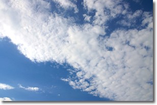
Similar to cirrocumulus clouds, altocumulus clouds are characterized by cloud patches. They are distinguished by larger cloudlets than cirrocumulus clouds but are still smaller than stratocumulus clouds.

Altocumulus clouds most commonly form in middle altitudes (between 2 and 5 km) and may resemble, at times, the shape of a flying saucer. These uncommon formations, called altocumulus lenticularis, are created by uplift in the atmosphere and are most often seen in close proximity to mountains.

Next Topic: Altostratus Clouds

Weather Topic: What are Cirrocumulus Clouds?

Home - Education - Cloud Types - Cirrocumulus Clouds

Cirrocumulus Clouds Next Topic: Cirrostratus Clouds

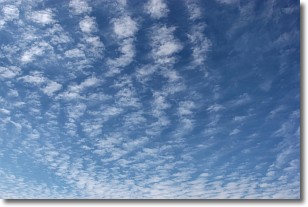
Cirrocumulus clouds form at high altitudes (usually around 5 km) and have distinguishing characteristics displayed in a fine layer of small cloud patches. These small cloud patches are sometimes referred to as "cloudlets" in relation to the whole cloud formation.

Cirrocumulus clouds are formed from ice crystals and water droplets. Often, the water droplets in the cloud freeze into ice crystals and the cloud becomes a cirrostratus cloud. Because of this common occurrence, cirrocumulus cloud formations generally pass rapidly.

Next Topic: Cirrostratus Clouds

Current conditions powered by WeatherAPI.com